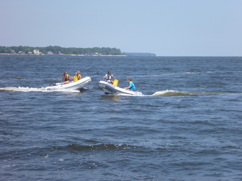
Mom and Dad decided to have us kids drive/sail the boat home tomorrow, with them being on standby, to see what we've learned the past six months. So us kids will do everything... planning the route, pulling up the anchor, driving, handling the sails... should be a lot of fun!
Next post will be from Havre de Grace!! See you all soon!
Wednesday, May 11, 2011
Tuesday, May 10, 2011
Almost Home!
We had a great time at Oriental, spending time with all of our friends. Twice we went out on the water with the Edwards, sailing F-Js and having dinghy-water fights. We were also able to reunite with Ruahk, who was staying in New Bern, and got to meet some of their friends in the area. We stayed at Oriental through Tuesday, with a surprise visit from our friends on Diamond on Monday and Tuesday! We had a lot of fun catching up and reminiscing with them.
We put in some long days after that, moving north. Wednesday we were on the south side of the Alligator River. Thursday we moved up to Broad Creek, which is north of the Albemarle Sound. Our original plan was to cross the sound Friday morning, but because Friday's weather was a little bit rough, we decided to put in the extra miles and cross it Thursday evening. We were all very glad we did.
Friday we stayed at the free wall at Great Bridge. We didn't think we were going to be able to stay there at first, because when we were waiting for the bridge to open right on the south side of the wall, the wall was full. Fortunately, a couple of the boats that were tied up to the wall were also waiting for the bridge, so they left, and we were able to get a spot on the wall. We went out for dinner at the Mexican Restaurant no more than a couple of blocks away. We have gone there every time we tie up at the wall - it's got great food at reasonable prices! At this point, we were traveling with a boat called White Seal, a 36 ft boat with a 17 year old girl on board. We had previously met them in Georgetown, and they are a lot of fun! They joined us for dinner, as well as a celebratory ice cream at Dairy Queen, because it was my mom's birthday the next day.
Saturday morning we left bright and early, wanting to arrive at our free slip in Hampton early. Last year, while traveling down the Chesapeake Bay, our friends on Messenger signed us up for a free night at the Hampton marina during the Annapolis boat show. We greatly appreciated that, as it made it much more convenient when my Uncle came to visit us. He lives in Virginia, and made the relatively short drive over to visit us. We had a fun visit, and he took my dad and brother to the store to stock up on some groceries that we needed to get home. However, the slip was right behind a bar, and they had loud music playing till all hours of the morning.
Sunday we left early and headed for Crisfield, MD. Crisfield is, unfortunately, a dying town. Last time we were in Crisfield, (which was on our last trip 7 years ago) we were able to go to the crab plant and watch them pick crabs and such. We were not able to do that this time however, because we arrived so late and they were already closed.
Monday we headed for Solomons. This was our first stop on the trip down, and we have been here many times for Trawler Fest's, which we used to come to every year. We had to take a layover day here, because the weather forecast for today was 10-15 kts of wind, which isn't to bad, but it was on our nose. There were also supposed to be 2-3 foot seas, also on our nose. That means we would have been pounding into them the whole day, with no sails to steady us. So we opted to stay here for the day. Christine, Mom and I took the bus to Calvert Cliffs, a state park famous for the sharks teeth that have been found there. We each found a couple, although they were not very big.
Tomorrow we plan on heading to Still Pond, an anchorage about 2 1/2 hours away from home. We should be able to make the run, although it's kind of long at 63 miles. But the wind looks slightly more favorable tomorrow, so hopefully we'll be able to put some sail up. Our current plan is to arrive home Thursday morning, but of course, we are boaters, so our plans are set in Jello!
 |
| A toast - To old friends and new! (with sparkling grape juice :) ) |
 |
| Dinghy water fights! |
 |
| Michael, Christine, Alexis, and Nicole sailing the F-J's! |
Sunday, May 8, 2011
Check-in/OK message from Tellup-2010 Cruise SPOT Personal Tracker
Tellup-2010 Cruise
Latitude:37.97679
Longitude:-75.85999
GPS location Date/Time:05/08/2011 23:52:29 GMT
Latitude:37.97679
Longitude:-75.85999
GPS location Date/Time:05/08/2011 23:52:29 GMT
Message:In the Bahamas!
Click the link below to see where I am located.
http://fms.ws/4lv9i/37.97679/\-75.85999
If the above link does not work, try this link:
http://maps.google.com/maps?f=q&hl=en&geocode=&q=37.97679,-75.85999&ll=37.97679,-75.85999&ie=UTF8&z=12&om=1
Tellup-2010 Cruise
You have received this message because Tellup-2010 Cruise has added you to their SPOT contact list.
Every day is an Adventure. Share Yours.
http://www.findmespot.com
Thursday, May 5, 2011
Check-in/OK message from Tellup-2010 Cruise SPOT Personal Tracker
Tellup-2010 Cruise
Latitude:36.21507
Longitude:-75.94061
GPS location Date/Time:05/06/2011 00:14:50 GMT
Latitude:36.21507
Longitude:-75.94061
GPS location Date/Time:05/06/2011 00:14:50 GMT
Message:In the Bahamas!
Click the link below to see where I am located.
http://fms.ws/4kZTn/36.21507/\-75.94061
If the above link does not work, try this link:
http://maps.google.com/maps?f=q&hl=en&geocode=&q=36.21507,-75.94061&ll=36.21507,-75.94061&ie=UTF8&z=12&om=1
Tellup-2010 Cruise
You have received this message because Tellup-2010 Cruise has added you to their SPOT contact list.
Every day is an Adventure. Share Yours.
http://www.findmespot.com
Check-in/OK message from Tellup-2010 Cruise SPOT Personal Tracker
Tellup-2010 Cruise
Latitude:35.67437
Longitude:-76.10242
GPS location Date/Time:05/05/2011 07:50:44 GMT
Latitude:35.67437
Longitude:-76.10242
GPS location Date/Time:05/05/2011 07:50:44 GMT
Message:In the Bahamas!
Click the link below to see where I am located.
http://fms.ws/4kCXG/35.67437/\-76.10242
If the above link does not work, try this link:
http://maps.google.com/maps?f=q&hl=en&geocode=&q=35.67437,-76.10242&ll=35.67437,-76.10242&ie=UTF8&z=12&om=1
Tellup-2010 Cruise
You have received this message because Tellup-2010 Cruise has added you to their SPOT contact list.
Every day is an Adventure. Share Yours.
http://www.findmespot.com
Check-in/OK message from Tellup-2010 Cruise SPOT Personal Tracker
Tellup-2010 Cruise
Latitude:35.67435
Longitude:-76.10226
GPS location Date/Time:05/05/2011 06:51:15 GMT
Latitude:35.67435
Longitude:-76.10226
GPS location Date/Time:05/05/2011 06:51:15 GMT
Message:In the Bahamas!
Click the link below to see where I am located.
http://fms.ws/4kBqb/35.67435/\-76.10226
If the above link does not work, try this link:
http://maps.google.com/maps?f=q&hl=en&geocode=&q=35.67435,-76.10226&ll=35.67435,-76.10226&ie=UTF8&z=12&om=1
Tellup-2010 Cruise
You have received this message because Tellup-2010 Cruise has added you to their SPOT contact list.
Every day is an Adventure. Share Yours.
http://www.findmespot.com
Check-in/OK message from Tellup-2010 Cruise SPOT Personal Tracker
Tellup-2010 Cruise
Latitude:35.67443
Longitude:-76.10217
GPS location Date/Time:05/05/2011 05:51:15 GMT
Latitude:35.67443
Longitude:-76.10217
GPS location Date/Time:05/05/2011 05:51:15 GMT
Message:In the Bahamas!
Click the link below to see where I am located.
http://fms.ws/4kB54/35.67443/\-76.10217
If the above link does not work, try this link:
http://maps.google.com/maps?f=q&hl=en&geocode=&q=35.67443,-76.10217&ll=35.67443,-76.10217&ie=UTF8&z=12&om=1
Tellup-2010 Cruise
You have received this message because Tellup-2010 Cruise has added you to their SPOT contact list.
Every day is an Adventure. Share Yours.
http://www.findmespot.com
Wednesday, May 4, 2011
Check-in/OK message from Tellup-2010 Cruise SPOT Personal Tracker
Tellup-2010 Cruise
Latitude:35.67441
Longitude:-76.10214
GPS location Date/Time:05/05/2011 03:51:14 GMT
Latitude:35.67441
Longitude:-76.10214
GPS location Date/Time:05/05/2011 03:51:14 GMT
Message:In the Bahamas!
Click the link below to see where I am located.
http://fms.ws/4k9Xr/35.67441/\-76.10214
If the above link does not work, try this link:
http://maps.google.com/maps?f=q&hl=en&geocode=&q=35.67441,-76.10214&ll=35.67441,-76.10214&ie=UTF8&z=12&om=1
Tellup-2010 Cruise
You have received this message because Tellup-2010 Cruise has added you to their SPOT contact list.
Every day is an Adventure. Share Yours.
http://www.findmespot.com
Check-in/OK message from Tellup-2010 Cruise SPOT Personal Tracker
Tellup-2010 Cruise
Latitude:35.67441
Longitude:-76.10217
GPS location Date/Time:05/05/2011 01:51:28 GMT
Latitude:35.67441
Longitude:-76.10217
GPS location Date/Time:05/05/2011 01:51:28 GMT
Message:In the Bahamas!
Click the link below to see where I am located.
http://fms.ws/4k7jt/35.67441/\-76.10217
If the above link does not work, try this link:
http://maps.google.com/maps?f=q&hl=en&geocode=&q=35.67441,-76.10217&ll=35.67441,-76.10217&ie=UTF8&z=12&om=1
Tellup-2010 Cruise
You have received this message because Tellup-2010 Cruise has added you to their SPOT contact list.
Every day is an Adventure. Share Yours.
http://www.findmespot.com
Saturday, April 30, 2011
moving north!
We woke up Easter morning in Winyah Bay, and motored three miles to a free dock in Georgetown, so we could go to church. We found a church that was built in the 1700's and our family was assigned to a 'pew box'. The music was good and the people there were very friendly. We left Georgetown after a quick Easter breakfast and continued our journey north.
For the next several days, we put in lots of miles, which was challenging because we had to work around bridge opening schedules and live-firing exercises at Camp LeJeune. We arrived in Oriental Thursday mid morning, a few hours before severe wind hit. We had a great south wind, and sailed across the Neuse River at 8.5 knots. We've enjoyed spending time with our old cruising friends, Green Dolphin, and we visited with Ruahk who is keeping there boat in New Bern for a few weeks. On Friday Michael and I (Christine) went sailing with Alexis and Nicole, to try out some new Flying-Js they got for their sailing school. We had a great time and lots of wind. We're planning to stay here a few more days, then continue our push north. We're hoping spring catches up with us again... we've had to dig out the sweatshirts!
For the next several days, we put in lots of miles, which was challenging because we had to work around bridge opening schedules and live-firing exercises at Camp LeJeune. We arrived in Oriental Thursday mid morning, a few hours before severe wind hit. We had a great south wind, and sailed across the Neuse River at 8.5 knots. We've enjoyed spending time with our old cruising friends, Green Dolphin, and we visited with Ruahk who is keeping there boat in New Bern for a few weeks. On Friday Michael and I (Christine) went sailing with Alexis and Nicole, to try out some new Flying-Js they got for their sailing school. We had a great time and lots of wind. We're planning to stay here a few more days, then continue our push north. We're hoping spring catches up with us again... we've had to dig out the sweatshirts!
Charleston, SC
The ICW in Georgia can be challenging due to lots of shoaling. For this reason we had hoped to go outside, but the weather never cooperated with us. A lot of the Georgia and South Carolina ICW runs through remote swamp lands, so it can be either very boring, or a great opportunity to see wildlife, depending on your point of view. It's also very buggy. One time when Mom went to take Tazzie to shore, she had to wear long pants and a rain jacket, just to keep the bugs off. The few days prior to this, we had only been able to take Tazzie to a few small oyster beds so she hadn't had much exercise. At the South Edisto River anchorage, there is a dock, and Mom was going to let Tazzie off the leash to run. However, the bugs were so bad that Mom decided to keep her on the leash and just go for a quick walk. Several yards down the path, Mom looked over the bank and saw an alligator staring hungrily at Tazzie. After Mom got a picture, she decided it was time to turn around and head back to the boat.
 |
| cruising up the ICW |
Our next stop was Charleston, South Carolina. Dad had some work to do on the boat which required a marina, so we went into Charleston Maritime Center for two days. We enjoyed walking around and admiring the architecture of the houses in this historic city. We walked down the the Battery, and found the house where Mom's uncle used to live.
 |
| The walk to the Battery was 'fun'. We were caught in a major downpour and were soaked. This is me dumping water out of my shoes. |

 |
| We stopped at a really cool frozen yogurt shop in Charleston. |
On our way out of Charleston, we took our boat to Fort Sumter and got a head start on next year's study of American History.

Wednesday, April 27, 2011
Check-in/OK message from Tellup-2010 Cruise SPOT Personal Tracker
Tellup-2010 Cruise
Latitude:34.71978
Longitude:-76.70944
GPS location Date/Time:04/28/2011 00:05:56 GMT
Latitude:34.71978
Longitude:-76.70944
GPS location Date/Time:04/28/2011 00:05:56 GMT
Message:In the Bahamas!
Click the link below to see where I am located.
http://fms.ws/4h6Xt/34.71978/\-76.70944
If the above link does not work, try this link:
http://maps.google.com/maps?f=q&hl=en&geocode=&q=34.71978,-76.70944&ll=34.71978,-76.70944&ie=UTF8&z=12&om=1
Tellup-2010 Cruise
You have received this message because Tellup-2010 Cruise has added you to their SPOT contact list.
Every day is an Adventure. Share Yours.
http://www.findmespot.com
Tuesday, April 26, 2011
Some pictures from the past week...
 |
| Our biggest catch so far... jumped in our dinghy a couple of nights ago... We have no idea what kind of fish it is, though.. |
 |
| Erin listening to music on the boom... |
 |
| Michael hanging out in his new hammock. |
 |
| Tazzie taking a snooze on the boat |

Saturday, April 23, 2011
Check-in/OK message from Tellup-2010 Cruise SPOT Personal Tracker
Tellup-2010 Cruise
Latitude:33.31337
Longitude:-79.28931
GPS location Date/Time:04/24/2011 01:19:49 GMT
Latitude:33.31337
Longitude:-79.28931
GPS location Date/Time:04/24/2011 01:19:49 GMT
Message:In the Bahamas!
Click the link below to see where I am located.
http://fms.ws/4fevU/33.31337/\-79.28931
If the above link does not work, try this link:
http://maps.google.com/maps?f=q&hl=en&geocode=&q=33.31337,-79.28931&ll=33.31337,-79.28931&ie=UTF8&z=12&om=1
Tellup-2010 Cruise
You have received this message because Tellup-2010 Cruise has added you to their SPOT contact list.
Every day is an Adventure. Share Yours.
http://www.findmespot.com
Wednesday, April 20, 2011
Check-in/OK message from Tellup-2010 Cruise SPOT Personal Tracker
Tellup-2010 Cruise
Latitude:32.61876
Longitude:-80.3996
GPS location Date/Time:04/21/2011 01:41:59 GMT
Latitude:32.61876
Longitude:-80.3996
GPS location Date/Time:04/21/2011 01:41:59 GMT
Message:In the Bahamas!
Click the link below to see where I am located.
http://fms.ws/4eIVt/32.61876/\-80.3996
If the above link does not work, try this link:
http://maps.google.com/maps?f=q&hl=en&geocode=&q=32.61876,-80.3996&ll=32.61876,-80.3996&ie=UTF8&z=12&om=1
Tellup-2010 Cruise
You have received this message because Tellup-2010 Cruise has added you to their SPOT contact list.
Every day is an Adventure. Share Yours.
http://www.findmespot.com
Check-in/OK message from Tellup-2010 Cruise SPOT Personal Tracker
Tellup-2010 Cruise
Latitude:32.1305
Longitude:-80.88629
GPS location Date/Time:04/20/2011 12:16:51 GMT
Latitude:32.1305
Longitude:-80.88629
GPS location Date/Time:04/20/2011 12:16:51 GMT
Message:In the Bahamas!
Click the link below to see where I am located.
http://fms.ws/4d_B-/32.1305/\-80.88629
If the above link does not work, try this link:
http://maps.google.com/maps?f=q&hl=en&geocode=&q=32.1305,-80.88629&ll=32.1305,-80.88629&ie=UTF8&z=12&om=1
Tellup-2010 Cruise
You have received this message because Tellup-2010 Cruise has added you to their SPOT contact list.
Every day is an Adventure. Share Yours.
http://www.findmespot.com
Check-in/OK message from Tellup-2010 Cruise SPOT Personal Tracker
Tellup-2010 Cruise
Latitude:32.08875
Longitude:-80.93292
GPS location Date/Time:04/20/2011 11:17:27 GMT
Latitude:32.08875
Longitude:-80.93292
GPS location Date/Time:04/20/2011 11:17:27 GMT
Message:In the Bahamas!
Click the link below to see where I am located.
http://fms.ws/4d-Dq/32.08875/\-80.93292
If the above link does not work, try this link:
http://maps.google.com/maps?f=q&hl=en&geocode=&q=32.08875,-80.93292&ll=32.08875,-80.93292&ie=UTF8&z=12&om=1
Tellup-2010 Cruise
You have received this message because Tellup-2010 Cruise has added you to their SPOT contact list.
Every day is an Adventure. Share Yours.
http://www.findmespot.com
Monday, April 18, 2011
Check-in/OK message from Tellup-2010 Cruise SPOT Personal Tracker
Tellup-2010 Cruise
Latitude:31.36532
Longitude:-81.33075
GPS location Date/Time:04/19/2011 00:38:58 GMT
Latitude:31.36532
Longitude:-81.33075
GPS location Date/Time:04/19/2011 00:38:58 GMT
Message:In the Bahamas!
Click the link below to see where I am located.
http://fms.ws/4dOJ9/31.36532/\-81.33075
If the above link does not work, try this link:
http://maps.google.com/maps?f=q&hl=en&geocode=&q=31.36532,-81.33075&ll=31.36532,-81.33075&ie=UTF8&z=12&om=1
Tellup-2010 Cruise
You have received this message because Tellup-2010 Cruise has added you to their SPOT contact list.
Every day is an Adventure. Share Yours.
http://www.findmespot.com
Cumberland Island; 4/16-4/18
After saying goodbye to Diamond, the family we've been traveling with since February, we headed north toward Cumberland Island, Georgia.
It was a great morning for sailing. At one point we got up to 9.7 knots. However, the afternoon brought many challenges. First of all, the tide was dropping, and since there's been a full moon lately, the tides have been even lower than normal. We hit bottom several times, but were able to plow through the mud to deeper water. At the same time, the winds picked up into the 40 knot range. We decided to bail out on our plans to go to Cumberland Island and stay in a marina to get out of the wind. Fernandina Beach had no slips or mooring balls available. We secured a slip in another marina, but when we arrived, we found out that their entrance channel only has three feet of water at low tide. We would've had to wait two hours in the howling wind to enter. So, we continued north across the Cumberland Sound. In the sound, we had waves to deal with along with the wind, which made for an exciting trip. We were happy to tuck in next to Cumberland Island, and we got a good set with our anchor. The wind continued to get stronger, and it blew our American flag off the halyard and into the water.
By evening the wind settled down, we were able to get a good night sleep and we woke up to a beautiful morning. Mom's goal was to spend the whole day exploring the island, and we all took turns accompanying her. The island, which is only accessible by boat, has sixteen miles of beach, a campground, and ruins of The Dungeness, which was a mansion owned by the Carnegie family. So we learned a little history, added to our shell collection, and got plenty of exercise.
Here are some pics from Cumberland Island...


Here are some pics from Cumberland Island...


Saturday, April 16, 2011
Check-in/OK message from Tellup-2010 Cruise SPOT Personal Tracker
Tellup-2010 Cruise
Latitude:30.77315
Longitude:-81.4707
GPS location Date/Time:04/16/2011 22:58:41 GMT
Latitude:30.77315
Longitude:-81.4707
GPS location Date/Time:04/16/2011 22:58:41 GMT
Message:In the Bahamas!
Click the link below to see where I am located.
http://fms.ws/4cTb_/30.77315/\-81.4707
If the above link does not work, try this link:
http://maps.google.com/maps?f=q&hl=en&geocode=&q=30.77315,-81.4707&ll=30.77315,-81.4707&ie=UTF8&z=12&om=1
Tellup-2010 Cruise
You have received this message because Tellup-2010 Cruise has added you to their SPOT contact list.
Every day is an Adventure. Share Yours.
http://www.findmespot.com
Friday, April 15, 2011
Crossing back to the States
There's not a lot of civilization west of Green Turtle Cay. There is one marina at West End, which provides the shortest jump to Florida, and we were planning to stop there, and leave at first light for Florida. However, when we called, we found out it would cost over $150 dollars to tie up our boat for one night. So, we decided to skip the marina. We spent one night at Allans-Pensacola and one night at Mangrove Cay. Both are uninhabited islands and we tried to absorb every moment of our last days in the Bahamas. We left Mangrove Cay at 4 am, Friday the 8th, and arrived Ft. Pierce at 8:30 pm.
We picked a calm day (maybe too calm) for the crossing, so we had to motor-sail the whole day. It was pretty slow moving until we hit the Gulf Stream, where we turned north and hit a record breaking 10.7 knots. Midway through the stream, we wrote a note, put it in a glass bottle, and tossed it overboard. We're hoping someone in some far-away place finds it and contacts us. The highlight of the trip was being entertained by a pod of 12 dolphins who were swimming and playing around our boat. They spent a lot of time riding our bow waves and swimming under the boat.
We are now at St. Augustine, beginning to work our way north on the ICW, stopping at Vero Beach and New Smyrna. It's been interesting adjusting to the culture shock. There is so much noise and so many lights. The first night we were wondering who turned out the stars. However, we certainly have enjoyed Subway, Chinese food, and free showers and water, and cheap laundry. We are still traveling with Diamond, and we had a grand reunion with Ruahk when we caught up with them here in St. Augustine. Ruahk has since left for a three day passage outside to North Carolina, and Diamond is going to be staying here for a week, touring Cape Canaveral and going to Disney. We'll start our trek north tomorrow at first light.
Pictures will be coming soon!
Wednesday, April 13, 2011
Man O'War to Green Turtle!

Man O'War was a nice little community and Friday night we went to a community concert. The kids had fun with some of the Bahamian teenagers, so now we have some Bahamian Facebook friends! We also sampled some more Bahamian food after the concert.

From Man O'War, it's another short sail to Green Turtle Cay. However, to get there you have to go through Whale Cut. Whale Cut is famous for producing a "rage" effect. A "rage" is rough and sometime dangerous waves that occur in narrow channels when wind opposes tide. We waited for a calm morning to go through, and thankfully the water was flat! At Green Turtle Cay, we rented a golf cart to drive into town to get some supplies. We also drove by a gorgeous beach overlook.

We anchored the first night at Green Turtle, but there was a front coming through so we moved into the marina. Green Turtle Cay marina was a little bit on the expensive side, but we were able to "eat our dockage." Basically, everything we spent at the restaurant and bar came off of our docking fee. Our only choice was to eat enough food to cover the cost of the marina. The boats we have been traveling with (Diamond, Falco, and Messenger) all decided to join us! That made for a big party of 18!


Tuesday, April 12, 2011
Check-in/OK message from Tellup-2010 Cruise SPOT Personal Tracker
Tellup-2010 Cruise
Latitude:29.89547
Longitude:-81.30972
GPS location Date/Time:04/13/2011 02:01:12 GMT
Latitude:29.89547
Longitude:-81.30972
GPS location Date/Time:04/13/2011 02:01:12 GMT
Message:In the Bahamas!
Click the link below to see where I am located.
http://fms.ws/4aocd/29.89547/\-81.30972
If the above link does not work, try this link:
http://maps.google.com/maps?f=q&hl=en&geocode=&q=29.89547,-81.30972&ll=29.89547,-81.30972&ie=UTF8&z=12&om=1
Tellup-2010 Cruise
You have received this message because Tellup-2010 Cruise has added you to their SPOT contact list.
Every day is an Adventure. Share Yours.
http://www.findmespot.com
Friday, April 8, 2011
Check-in/OK message from Tellup-2010 Cruise SPOT Personal Tracker
Tellup-2010 Cruise
Latitude:27.467
Longitude:-80.32675
GPS location Date/Time:04/09/2011 00:58:28 GMT
Latitude:27.467
Longitude:-80.32675
GPS location Date/Time:04/09/2011 00:58:28 GMT
Message:In the Bahamas!
Click the link below to see where I am located.
http://fms.ws/4Z6WX/27.467/\-80.32675
If the above link does not work, try this link:
http://maps.google.com/maps?f=q&hl=en&geocode=&q=27.467,-80.32675&ll=27.467,-80.32675&ie=UTF8&z=12&om=1
Tellup-2010 Cruise
You have received this message because Tellup-2010 Cruise has added you to their SPOT contact list.
Every day is an Adventure. Share Yours.
http://www.findmespot.com
Thursday, April 7, 2011
Check-in/OK message from Tellup-2010 Cruise SPOT Personal Tracker
Tellup-2010 Cruise
Latitude:26.92052
Longitude:-78.6217
GPS location Date/Time:04/07/2011 21:39:50 GMT
Latitude:26.92052
Longitude:-78.6217
GPS location Date/Time:04/07/2011 21:39:50 GMT
Message:In the Bahamas!
Click the link below to see where I am located.
http://fms.ws/4YdTC/26.92052/\-78.6217
If the above link does not work, try this link:
http://maps.google.com/maps?f=q&hl=en&geocode=&q=26.92052,-78.6217&ll=26.92052,-78.6217&ie=UTF8&z=12&om=1
Tellup-2010 Cruise
You have received this message because Tellup-2010 Cruise has added you to their SPOT contact list.
Every day is an Adventure. Share Yours.
http://www.findmespot.com
Wednesday, April 6, 2011
Check-in/OK message from Tellup-2010 Cruise SPOT Personal Tracker
Tellup-2010 Cruise
Latitude:26.98971
Longitude:-77.69131
GPS location Date/Time:04/06/2011 22:24:22 GMT
Latitude:26.98971
Longitude:-77.69131
GPS location Date/Time:04/06/2011 22:24:22 GMT
Message:In the Bahamas!
Click the link below to see where I am located.
http://fms.ws/4YDwV/26.98971/\-77.69131
If the above link does not work, try this link:
http://maps.google.com/maps?f=q&hl=en&geocode=&q=26.98971,-77.69131&ll=26.98971,-77.69131&ie=UTF8&z=12&om=1
Tellup-2010 Cruise
You have received this message because Tellup-2010 Cruise has added you to their SPOT contact list.
Every day is an Adventure. Share Yours.
http://www.findmespot.com
Saturday, April 2, 2011
Check-in/OK message from Tellup-2010 Cruise SPOT Personal Tracker
Tellup-2010 Cruise
Latitude:26.74527
Longitude:-77.30005
GPS location Date/Time:04/02/2011 19:59:29 GMT
Latitude:26.74527
Longitude:-77.30005
GPS location Date/Time:04/02/2011 19:59:29 GMT
Message:In the Bahamas!
Click the link below to see where I am located.
http://fms.ws/4Wbvi/26.74527/\-77.30005
If the above link does not work, try this link:
http://maps.google.com/maps?f=q&hl=en&geocode=&q=26.74527,-77.30005&ll=26.74527,-77.30005&ie=UTF8&z=12&om=1
Tellup-2010 Cruise
You have received this message because Tellup-2010 Cruise has added you to their SPOT contact list.
Every day is an Adventure. Share Yours.
http://www.findmespot.com
Wednesday, March 30, 2011
Check-in/OK message from Tellup-2010 Cruise SPOT Personal Tracker
Tellup-2010 Cruise
Latitude:26.58991
Longitude:-77.0014
GPS location Date/Time:03/30/2011 18:09:57 GMT
Latitude:26.58991
Longitude:-77.0014
GPS location Date/Time:03/30/2011 18:09:57 GMT
Message:In the Bahamas!
Click the link below to see where I am located.
http://fms.ws/4VJ7H/26.58991/\-77.0014
If the above link does not work, try this link:
http://maps.google.com/maps?f=q&hl=en&geocode=&q=26.58991,-77.0014&ll=26.58991,-77.0014&ie=UTF8&z=12&om=1
Tellup-2010 Cruise
You have received this message because Tellup-2010 Cruise has added you to their SPOT contact list.
Every day is an Adventure. Share Yours.
http://www.findmespot.com
Tuesday, March 29, 2011
Spanish Wells to Hopetown Abacos! 3/19-3/28
While waiting for good weather to cross to the Abacos, we took our dinghys to an island next to Spanish Wells, and walked three miles to a cave. This cave was a temporary home for some people who were shipwrecked in the 1600's who came from England to escape religious persecution.

 |
| Michael with the lobster on his spear |
 Mom and I went shelling on a beach and tidal creek, where we found lots of sand dollars, sea biscuits, and a helmet conch.
We arrived at Marsh Harbor and felt like we had returned to Forida. It was a big town, with lots of people and cars. There was even a stoplight! (although it was broken!) We were finally able to experience an evening of Rake and Scrape. This is a kind of music played by dragging a nail down the blade of a saw. They sometimes also use a washtub with a broomstick and a string attached to make a base. There is also a congo drum. The Bahamian men sing along!

Our next destination was a quaint harbor village called Hopetown. The cottages are painted with bright colors and all the streets are the width of a golf cart! While exploring the town we relaxed in some cute colorful chairs we found on a dock.

 |
 We were worried about the Abacos being chilly because they are so far north, but a south wind has been blowing so it is very warm here, which makes for great snorkeling weather!
Hopetown is famous for being home to one of the three remaining manually operated lighthouses in the world. It is open for visitors during the day, and we took the opportunity to climb it's 101 stairs all the way to the top!

 From the top of the lighthouse, you have a spectacular view of the harbor at Hopetown and the Sea of Abaco.
Sunday, March 27, 2011
Check-in/OK message from Tellup-2010 Cruise SPOT Personal Tracker
Tellup-2010 Cruise
Latitude:26.53919
Longitude:-76.95984
GPS location Date/Time:03/28/2011 03:27:50 GMT
Latitude:26.53919
Longitude:-76.95984
GPS location Date/Time:03/28/2011 03:27:50 GMT
Message:In the Bahamas!
Click the link below to see where I am located.
http://fms.ws/4UOSa/26.53919/\-76.95984
If the above link does not work, try this link:
http://maps.google.com/maps?f=q&hl=en&geocode=&q=26.53919,-76.95984&ll=26.53919,-76.95984&ie=UTF8&z=12&om=1
Tellup-2010 Cruise
You have received this message because Tellup-2010 Cruise has added you to their SPOT contact list.
Every day is an Adventure. Share Yours.
http://www.findmespot.com
Thursday, March 24, 2011
Check-in/OK message from Tellup-2010 Cruise SPOT Personal Tracker
Tellup-2010 Cruise
Latitude:26.55065
Longitude:-77.05469
GPS location Date/Time:03/24/2011 19:58:22 GMT
Latitude:26.55065
Longitude:-77.05469
GPS location Date/Time:03/24/2011 19:58:22 GMT
Message:In the Bahamas!
Click the link below to see where I am located.
http://fms.ws/4T3nv/26.55065/\-77.05469
If the above link does not work, try this link:
http://maps.google.com/maps?f=q&hl=en&geocode=&q=26.55065,-77.05469&ll=26.55065,-77.05469&ie=UTF8&z=12&om=1
Tellup-2010 Cruise
You have received this message because Tellup-2010 Cruise has added you to their SPOT contact list.
Every day is an Adventure. Share Yours.
http://www.findmespot.com
Wednesday, March 23, 2011
Check-in/OK message from Tellup-2010 Cruise SPOT Personal Tracker
Tellup-2010 Cruise
Latitude:26.38446
Longitude:-77.00641
GPS location Date/Time:03/23/2011 21:38:12 GMT
Latitude:26.38446
Longitude:-77.00641
GPS location Date/Time:03/23/2011 21:38:12 GMT
Message:In the Bahamas!
Click the link below to see where I am located.
http://fms.ws/4SjOK/26.38446/\-77.00641
If the above link does not work, try this link:
http://maps.google.com/maps?f=q&hl=en&geocode=&q=26.38446,-77.00641&ll=26.38446,-77.00641&ie=UTF8&z=12&om=1
Tellup-2010 Cruise
You have received this message because Tellup-2010 Cruise has added you to their SPOT contact list.
Every day is an Adventure. Share Yours.
http://www.findmespot.com
Friday, March 18, 2011
Alabaster Bay to Spanish Wells; 3/13 -3/18
After spending a night at Alabaster Bay and a night at Current Cut, we picked up a mooring ball in Spanish Wells.
 |
| Approaching Current Cut |
Spanish Wells is a small, bustling, fishing community, which supplies the Bahamas with half of all its seafood production.
 |
| Mom and Dad were impressed with the colorful, well kept homes here, but the highlight for us were the golf carts available to rent. |

We had met a family who was going across the island to deliver Creole Bibles to a Haitian settlement, and we tagged along with them

While the girls were visiting with the Haitian kids, Michael, Dad, Mr. Robnik (from Diamond) and his daughter Emily, went out lobstering.


Both Michael and Mr. Robnik brought home lobsters, and they were both ecstatic.


After dinner one evening, we were treated to a show by a pod of dolphins who swam around our boat for an hour.
 Then Michael treated us to a show of his own by swinging out over the water on the mainsail boom.
The moon is particularly close to the earth right now, which only happens once every 18 years. This means that the tides are more extreme, and Mom and Erin decided to take advantage of the really low tide, and enjoyed an afternoon of shelling.
 |
| Mom found a huge variety of unusual shells, but Erin wanted to see how many bubble shells she could find.... |
Tuesday, March 15, 2011
Check-in/OK message from Tellup-2010 Cruise SPOT Personal Tracker
Tellup-2010 Cruise
Latitude:25.54197
Longitude:-76.74557
GPS location Date/Time:03/15/2011 18:19:15 GMT
Latitude:25.54197
Longitude:-76.74557
GPS location Date/Time:03/15/2011 18:19:15 GMT
Message:In the Bahamas!
Click the link below to see where I am located.
http://fms.ws/4Pe91/25.54197/\-76.74557
If the above link does not work, try this link:
http://maps.google.com/maps?f=q&hl=en&geocode=&q=25.54197,-76.74557&ll=25.54197,-76.74557&ie=UTF8&z=12&om=1
Tellup-2010 Cruise
You have received this message because Tellup-2010 Cruise has added you to their SPOT contact list.
Every day is an Adventure. Share Yours.
http://www.findmespot.com
Monday, March 14, 2011
Check-in/OK message from Tellup-2010 Cruise SPOT Personal Tracker
Tellup-2010 Cruise
Latitude:25.41319
Longitude:-76.78815
GPS location Date/Time:03/14/2011 21:08:42 GMT
Latitude:25.41319
Longitude:-76.78815
GPS location Date/Time:03/14/2011 21:08:42 GMT
Message:In the Bahamas!
Click the link below to see where I am located.
http://fms.ws/4PJ5n/25.41319/\-76.78815
If the above link does not work, try this link:
http://maps.google.com/maps?f=q&hl=en&geocode=&q=25.41319,-76.78815&ll=25.41319,-76.78815&ie=UTF8&z=12&om=1
Tellup-2010 Cruise
You have received this message because Tellup-2010 Cruise has added you to their SPOT contact list.
Every day is an Adventure. Share Yours.
http://www.findmespot.com
Check-in/OK message from Tellup-2010 Cruise SPOT Personal Tracker
Tellup-2010 Cruise
Latitude:25.26422
Longitude:-76.31979
GPS location Date/Time:03/14/2011 14:08:58 GMT
Latitude:25.26422
Longitude:-76.31979
GPS location Date/Time:03/14/2011 14:08:58 GMT
Message:In the Bahamas!
Click the link below to see where I am located.
http://fms.ws/4P8vj/25.26422/\-76.31979
If the above link does not work, try this link:
http://maps.google.com/maps?f=q&hl=en&geocode=&q=25.26422,-76.31979&ll=25.26422,-76.31979&ie=UTF8&z=12&om=1
Tellup-2010 Cruise
You have received this message because Tellup-2010 Cruise has added you to their SPOT contact list.
Every day is an Adventure. Share Yours.
http://www.findmespot.com
Sunday, March 13, 2011
Rock Sound, 3/11-3/12
We spent two nights at Rock Sound. Our friends on Messenger suggested we have dinner at Rose's, on the north side beach. Rose serves meals on her back porch, overlooking the ocean. She cooks wonderful Bahamian food.
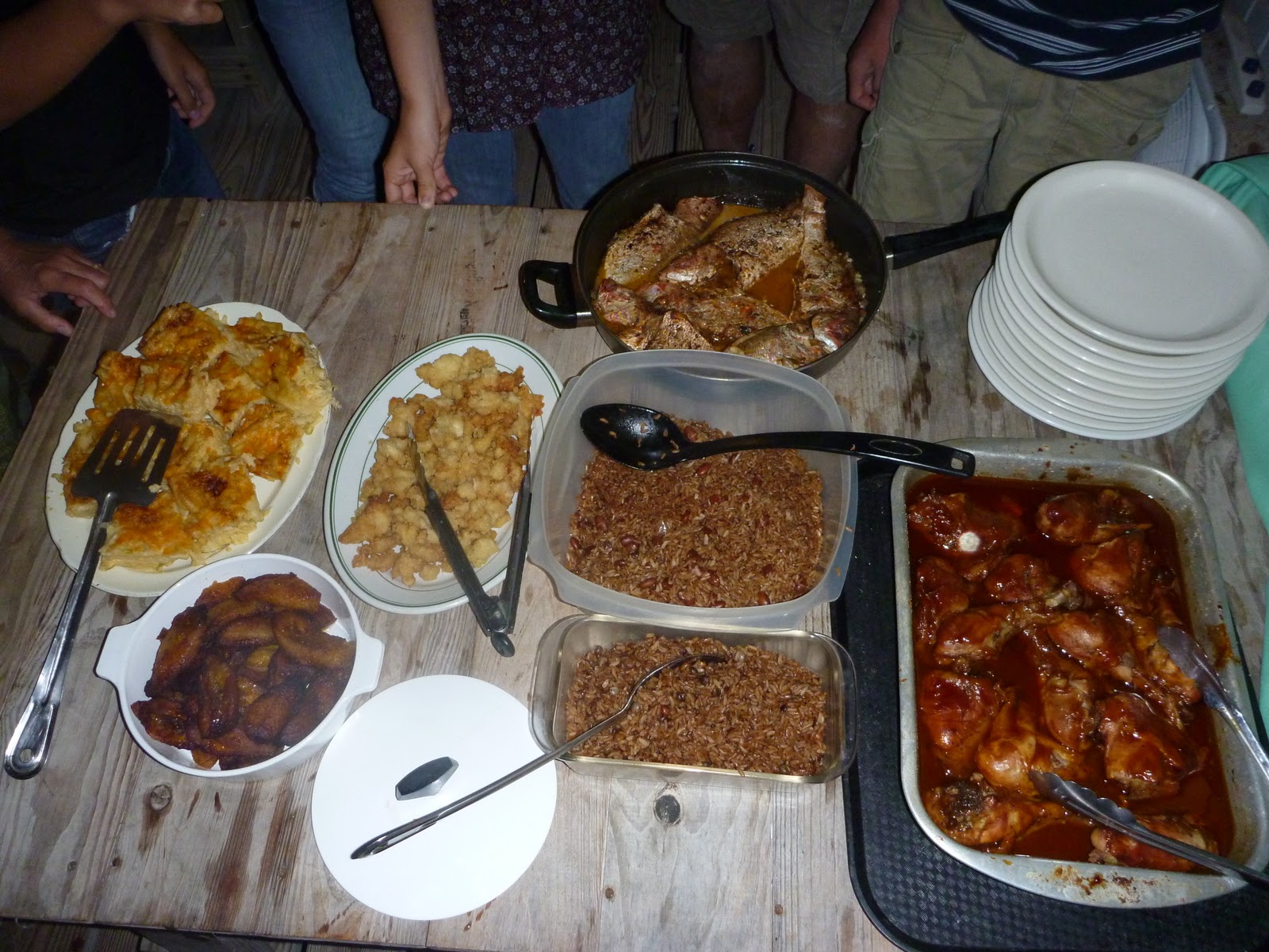
We had a buffet style dinner, which included: baked macaroni and cheese, steamed fish, barbecued and jerk chicken, peas and rice, beans and rice, fried conch, plantains, conch and vegetables, and coleslaw.
We were planning to leave early the next morning, but someone had told us about some caves on the island, and we didn't want to miss them.

The caves were amazing.

Trees from the ground above us had roots that extended down about twenty feet to the cave floor
Cape Eleuthera, Eleuthera. 3/10-3/11
On the island of Eleuthera, there is a school for high-school and college aged kids, who come from all over the US to spend a semester in the Bahamas, learning about ecology and human impact on the environment.
We were fortunate to be able to take a tour of the facilities.

The Island School grows food and is very self-supporting.
 |
| They were growing sweet potatoes and peanuts on the roof of a building. |
 |
| Us kids observing the various fish related experiments. |
 |
| More ways that the Island school is conserving energy and resources... using the fertilized fish waste water to grow lettuce and other greens |
Subscribe to:
Posts (Atom)